Trailer Load Balancing

Trailer Load Balancing For Safety

Trailer load balancing is important to understand because it is crucial to achieving a properly loaded trailer. We have all seen an overloaded trailer rolling down the highway at some point. Tree trucks, roofing materials, carpets, rock or tile and large boats all come to mind for unsafe trailer loading. Always remember, balance will make a huge difference in vehicle safety and stability and the end result is a safer, more comfortable ride.


Be safer by training employees to ensure properly loaded trailers.

Unbalanced loads are listed as the #3 towing risk according to the popular website How Stuff Works. The #1 towing risk cited is swaying. Sway primarily happens because of poor trailer load balance, so if you plan to tow, learn what you need to know about trailer load balance before you load.


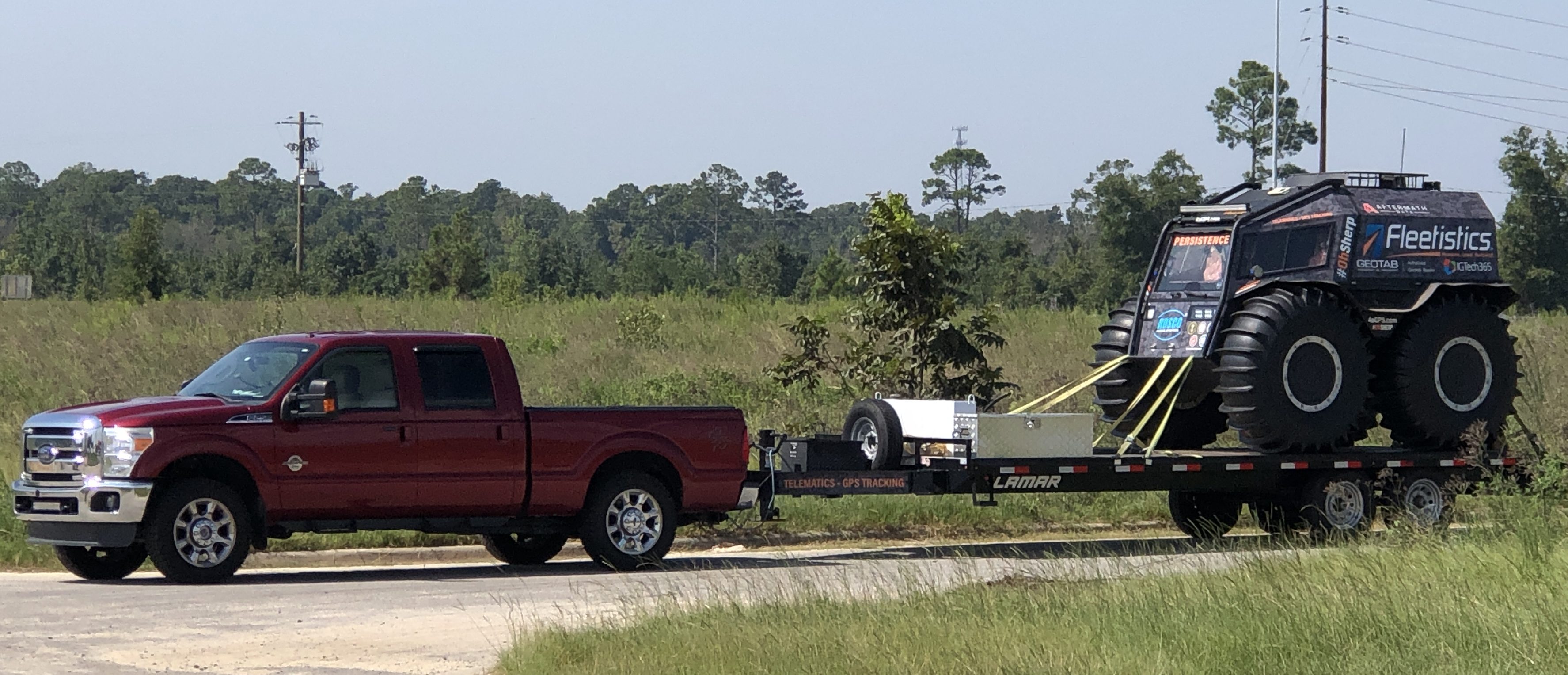
Trailer load balance with Sherp

Fleetistics Sherp Properly Loaded on Trailer


This dramatic video shows the importance of properly trailer load balancing. The effect of placing the majority of the load behind the trailer axle can dramatically impact handling. One might think that putting the load forward of the trailer tires would spread the load between the trailer and the truck but the impact on steering handling is a dangerous consequence.


The video is great continuing education content and is only a few minutes long. It is a real eye opener to the impact of improper loading. At the same time you can review trailer inspections, tongue weight, DOT regulations and maintenance.


Learn more about GPS trailer tracking

Smart City Innovations

Smart City Innovations

Smart City Technology is All Around Us

Smart City Technology is surfacing all over the United States. To most of us, smart city is a broad term used to describe how technology will make things better in the future, but it is hard to come up with a quick example of how technology actually makes a city smarter.

Smart 50 Awards in partnership with Smart Cities Connect honors the 50 most transformative smart projects each year. Among 2020 award recipients are several projects that rely upon GPS tracking and telematics. With that in mind, we have picked three of the 50 award winning projects to share with and inspire our readers. The official summaries of those winning projects follow.

San Jose Smart City

Smart City San Jose, CA

Emergency Response Times Improved

San Jose transformed traditional emergency vehicle preemption through a multi-domain solution expanding Central Traffic Management, integrating real-time CAD, and connecting vehicle presence. The results: response times fell by 24 seconds per trip benefiting life and safety; reduced accidents for first responders; and over $1.5 million in higher reimbursements.

After failing to meet mandated response times, the City of San Jose sought methods to improve response times. Traditional means to improve response times was through the further deployment of emergency vehicle preemption hardware to allow emergency vehicles faster passage to their destinations. In late 2016, emergency vehicle preemption equipment had been deployed at approximately one-third (or 336) of the city’s signalized intersections. Because this system required hardware installation at each intersection signal, system expansion and ongoing maintenance was too costly– at a rate of approximately 15 intersections per year, and an average cost of $15,000 per intersection and total cost of $9 million.

The City of San Jose made the decision to take a new approach to providing emergency vehicle preemption that leverages existing infrastructure and software systems already in use and eliminating the need for costly new hardware installation and maintenance. Creating a solution that is geo-aware, route in advance, real-time, and fast to deploy protects the lives and safety of residents, protects first responders from high in-transit accident rates, and provides the City with significantly higher revenue in the form of reimbursements.

Response times fell by 24 seconds per trip, preserving life and safety for residents Pre-cleared intersections reduce accidents for first responders in transit -Meeting response thresholds enables over $1.5 million in higher reimbursements from County partners -Solution saves the community 90% of the cost of traditional emergency preemption.

Pittsburgh Smart City

Smart City Pittsburgh, PA

Trash Collection Improvements

Sensors embedded within Pittsburgh’s trash receptacles measure the fill level of each container and transmit that information to the people responsible for servicing them. Waste collection process is made more efficient by only picking up containers above a certain fill level (e.g. 80%), saving money, time, and reducing environmental impact.
The project improves the efficiency of the waste collection process by measuring and reporting the fill level of every container, and then dispatching the collectors to only the containers which actually require collection. Pittsburgh sought to remove inefficiency within their trash pickup operation while reducing their carbon footprint and promoting costs savings. With the Relay system, they were able to maintain an accurate inventory of the locations and fill levels of more than 1,300 smart containers throughout the city.

The data gave them confidence in the decision to consolidate all of their containers into a centralized litter division, and also to reduce the staff responsible solely for picking up trash from 25 crew members down to 9. The 16 additional staff members have time to work on other tasks, which had been de-prioritized with the focus on trash collection. By picking up only the containers reaching 75% or 90% full, the city is saving money on truck drivers, laborers, fuel costs, equipment costs, and depreciation costs from the reduced wear and tear on collection trucks. Drastically cutting the amount of time these trucks are on the road also dramatically reduces the city’s environmental impact.

Streets are cleaner (less litter), containers are no longer overflowing, heavy diesel trucks are taken off the road (reducing greenhouse gas emissions and traffic delays to nearby drivers), taxpayer dollars are not going towards unnecessary trash collection, deferred public works responsibilities can have freed-up resources refocused on them.
Washington DC Smart City

Smart City Washington DC

Public Transit Improvements

Luminator Technology Group (Luminator) and the Washington Metropolitan Area Transit Authority (WMATA) partnered to install digital displays across the metro area to provide passenger information, including real-time arrival and departure times. The agency improved rider information and gained operational efficiencies through centrally managed updates.
In an effort to further connect the Washington D.C. metro area to real-time information, this implementation across the Washington Metro Area Transit Authority’s (WMATA) service area resulted in increased and improved access to key route information, with WMATA seamlessly updating displays and real-time data from a single location. By eliminating the need to manually update paper signs, the project brought mutual benefits to riders and the agency. Riders have access to real-time information incorporating any delays or closures, meanwhile, WMATA has decreased labor costs associated with manual changes of paper signage. With Luminator’s involvement in WMATA’s Capital Improvement Plan (CIP), the transit agency is able to provide information that increases the intelligence and efficiency of the solution, making stations brighter and easier-to-navigate. Luminator is also increasing efficiency throughout the system enabling future expansion.
WMATA currently has 400 of Luminator’s digital passenger information systems installed across its service area and will add another 400 over the next five years. With Luminator’s support, WMATA is improving and advancing these displays to meet the needs of approximately 120 million annual bus riders.

Congratulations to the Smart 50 Award Winners.

We congratulate all of the winners and look forward to participating with our City and County Government clients to welcome the future with Smart City initiatives. To learn more about the Smart 50 Awards visit https://spring.smartcitiesconnect.org/.
GEotab GO9 GPS Vehicle Tracking
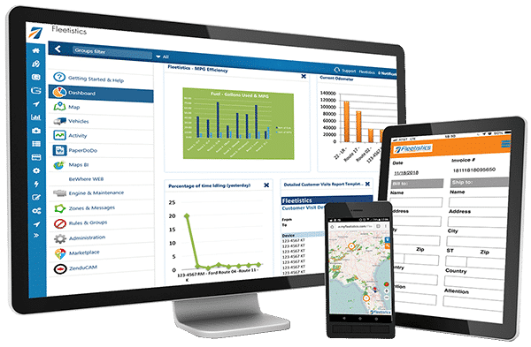
Fleet Management Platform
Mobile Phone GPS Tracking App
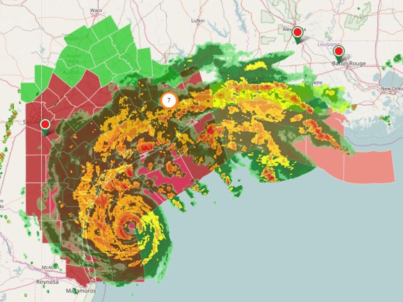
Fleet Weather Service

Green Fleet Dashboard to Visualize Your Changing Environmental Impact

Green Fleet Dashboard – Free Marketplace Add In

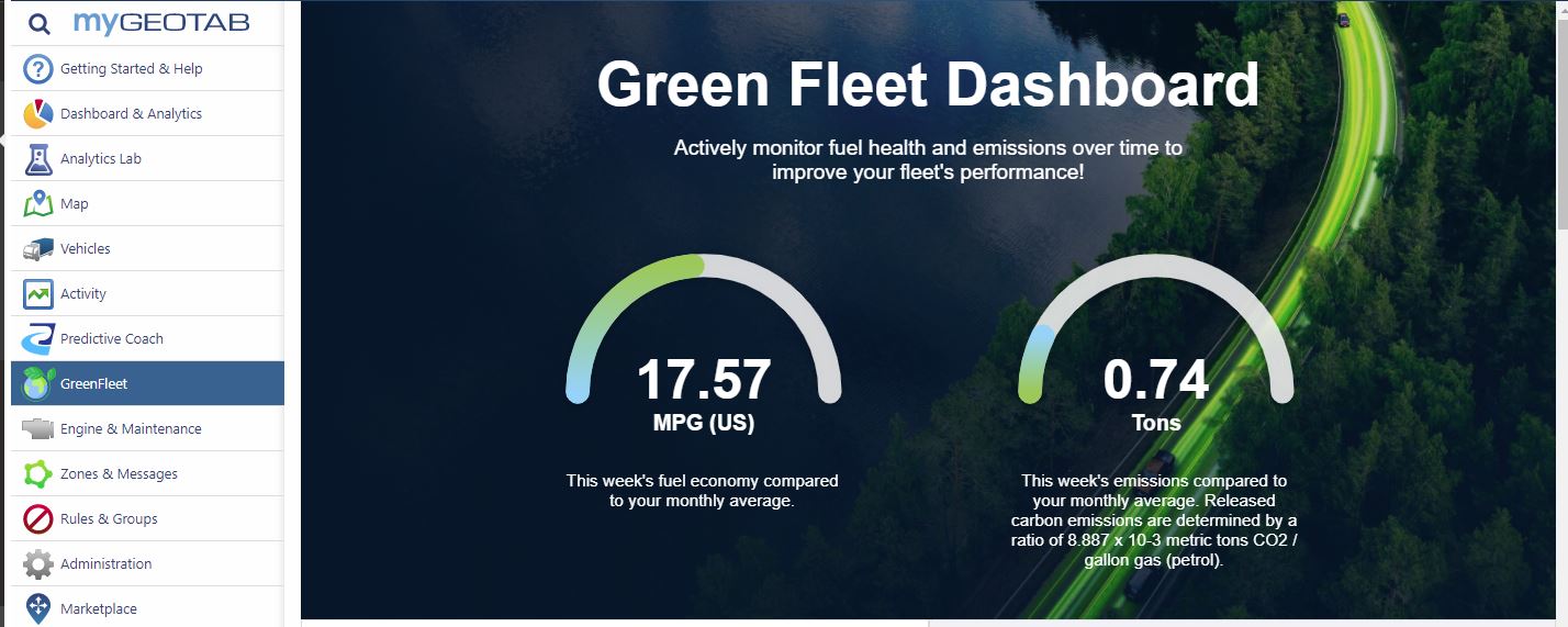
The Green Fleet Dashboard is one of Geotab’s latest innovations. It is a free add in available from the Geotab Marketplace. Have you seen it yet?

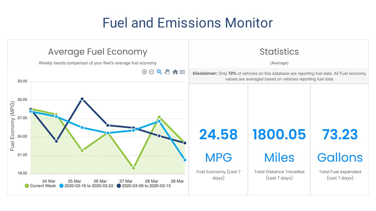
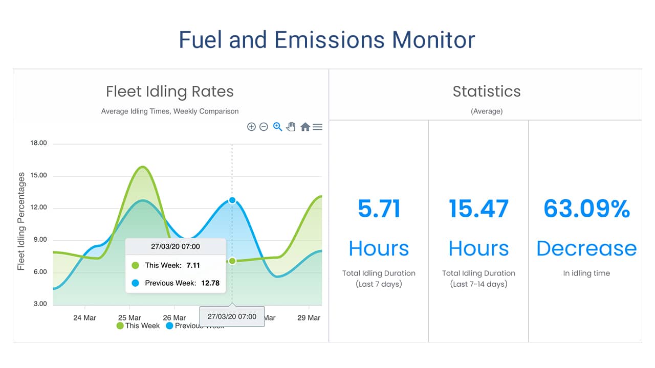
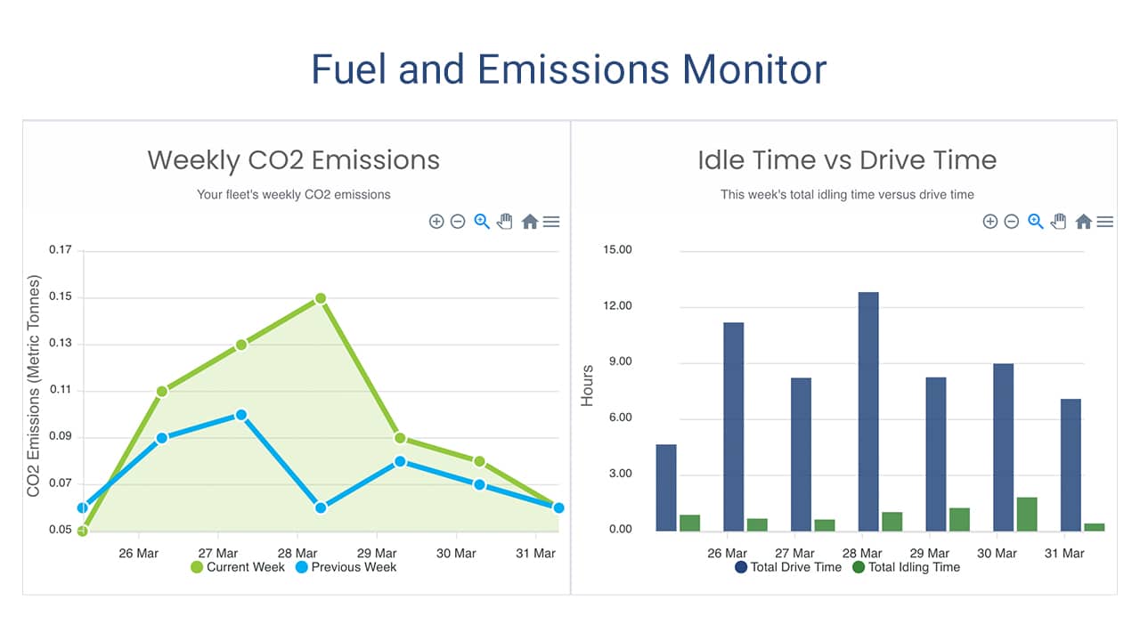
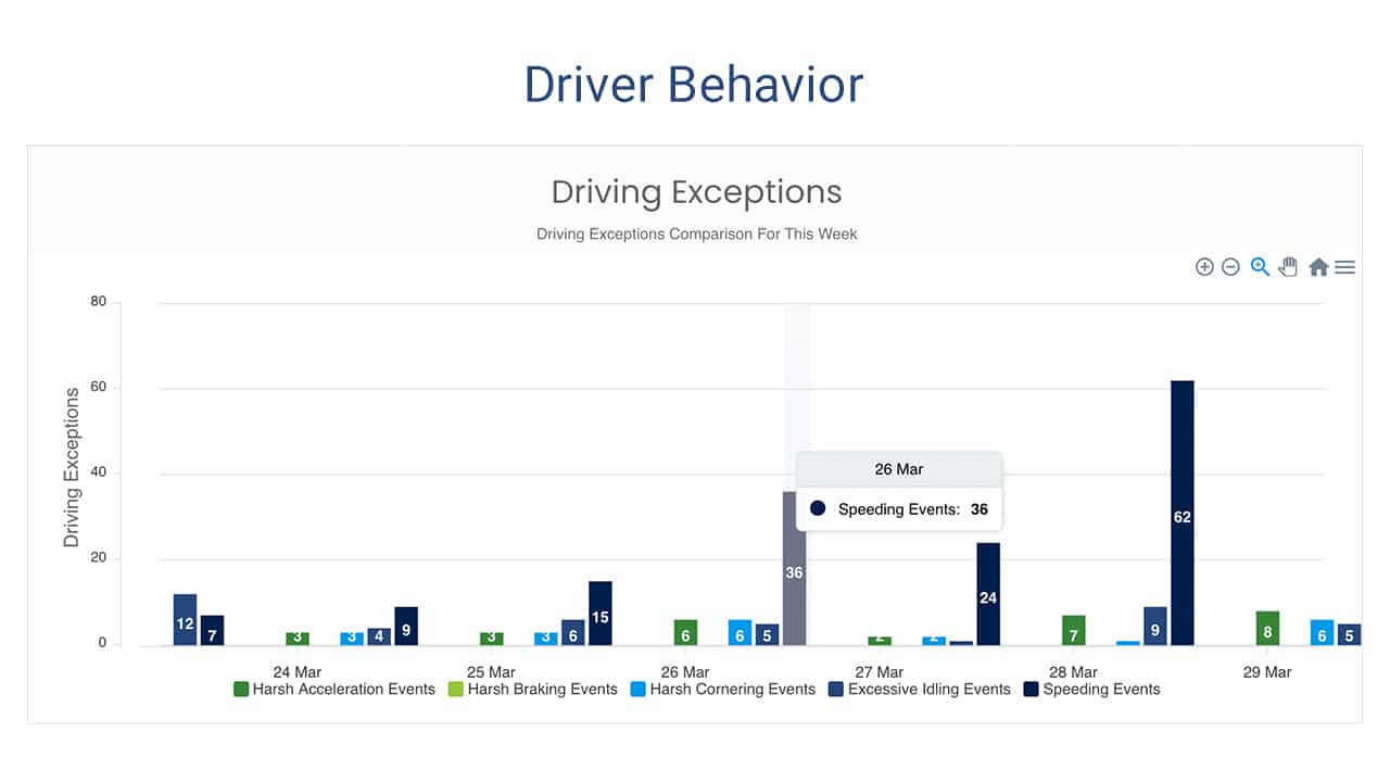
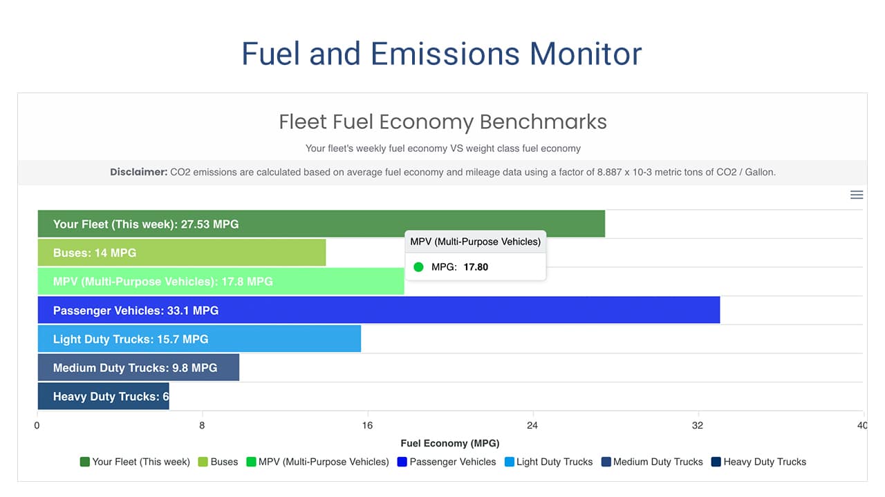
This add in displays a fleet’s efforts to reduce their environmental impact. It helps fleet managers to visualize their progress with improving fuel economy and reducing emissions. The dashboard provides key metrics on fuel useage and driving behaviors, that provide quick insight into how well your fleet is performing, and flags opportunities for improvement.

Green Fleet Dashboard

Green Fleet Dashboard Features

  • Monitor your fleet’s monthly and yearly average fuel economy
  • Track monthly and yearly emissions
  • Track key performance indicators related to fuel efficient driver behavior, including:
    • idling time
    • speed
    • harsh acceleration and braking
  • Highlight best and worst performers
  • Compare your fleet’s performance with fleet industry benchmarks

The Green Fleet Dashboard add in provides you with exceptional visual information. The graphics are easy to digest and keep you focused on achieving your green fleet goals. What a great tool to stay focused on reducing your environmental impact!

Below are some examples of the charts and graphs the Green Fleet Dashboard delivers.

Installing the Green Fleet Dashboard

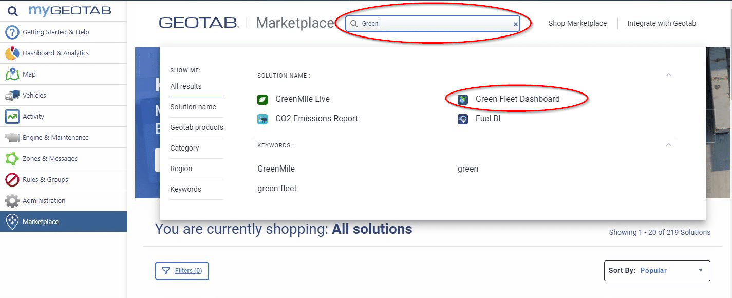
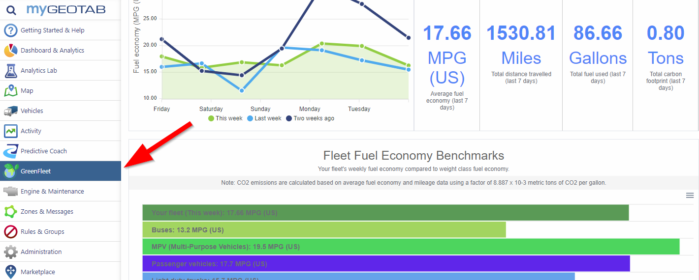
To install the add in, simply log into your Geotab account and select “Marketplace” at the bottom of the main menu. Once in the Marketplace, begin typing “green fleet” into the search bar until you see the Add In listed. Click on the add in logo, then click install on the next page. Once installed, you will see the new dashboard in your Geotab menu. Easy as 1-2-3!

Just click to expand the images below.

1

Search Geotab's Marketplace

2

Install Now

3

Green Fleet Dashboard Installed
GEotab GO9 GPS Vehicle Tracking
Fleet Management Platform
Mobile Phone GPS Tracking App
Fleet Weather Service

FMCSA Revisions to HOS Rules – Drivers and Dispatchers Respond

FMCSA Revisions to HOS Coming on 9/29/20

For quite some time we have been hearing about FMCSA revisions to the HOS rules intended to provide more flexibility for drivers. At long last, several are slated to be implemented the end of next month. We reached out to some of our current clients to get their take on the coming rule changes, and the response was quite positive.

What are the coming FMCSA revisions?

  • The on-duty limits for short-haul operations will increase from 12 to 14 hours and from 100 air-miles to 150.
  • The adverse driving provision will extend the driving window two hours if the driver encounters adverse driving conditions. In the final rule, the definition of adverse driving was modified so that the exception may be applied based on the driver’s (in addition to the dispatcher’s) knowledge of the conditions after being dispatched.
  • In addition to splits of 10/0 and 8/2, drivers will be allowed a split-sleeper option of 7/3. Also, the qualifying period doesn’t count against the 14-hour window.
  • The 30-minute break provision will be modified to require the break after eight hours of driving time (instead of on-duty time) and allows an on-duty/not driving period to qualify as the required break.
FMCSA Revisions

What are drivers and dispatchers saying?

They all sound like positive changes that will be helpful to drivers and dispatchers.
Scott Olson

Maier's transportation and Warehousing

I really like the changes to the 30 minute break provision. Now I won’t have to take a break after sitting at a terminal waiting to be loaded or unloaded.
Mike Zeug

Driver, Maier's Transportation and Warehousing

Most Outspoken Response to FMCSA Revisions

One of our clients was dead set against ELD from the beginning. He expected it to be a royal pain with drivers unwilling to embrace the new technology, and he fought it kicking and screaming, but in the end, had to comply. After implementing and using ELD for some time, his response was utterly shocking. Monty now agrees that ELD implementation is a good thing, and that it simplifies the driver’s record keeping saving time and frustration.

Regarding the FMCSA revisions coming to HOS Rules,

It should have been done a long time ago. It moves us from making political sense to using common sense. Most important are the sleeper berth changes. It allows a driver to make better use of unanticipated situations, for instance if the highway traffic is backed up he can pull off at a rest stop to take 3 hours sleeper berth time. Since it does not count against his 14 hour window, he can make up his lost travel time after the traffic clears.
Monty Hack

Fleet Manager - Safety Director, JS Weipz

OOIDA’s Response

Owner-Operator Independent Drivers Association expressed support for the final rule by filing formal comments. They say the new rules will accomplish FMCSA’s intended goal of providing drivers with more flexibility and control over their own schedules.
GEotab GO9 GPS Vehicle Tracking
Fleet Management Platform
Mobile Phone GPS Tracking App
Fleet Weather Service

Usage Based Insurance, Powered by Telematics

What is Usage Based Insurance?

Usage Based Insurance, or UBI, is defined by the National Association of Insurance Commissioners as a type of auto insurance that tracks mileage and driving behaviors. They further explain that the basic idea of UBI is that a driver’s behavior is monitored directly while the person drives, allowing insurers to more closely align driving behaviors with premium rates.

How UBI Works

Underwriters can now consider factors that formerly were not available. Total miles driven, time of day, geographic location, and road type all speak to driving conditions and insurance liability. Speed, rapid acceleration, hard braking, and hard cornering are behaviors known to directly impact accident risk. Obviously actual automobile usage is a more accurate method to assess risk than the actuarial methods in use. Actuarial methods aggregate accident risk based on age, gender, marital status, credit score, and driving history. Consequently UBI is a much fairer way to assign risk and set insurance premiums.

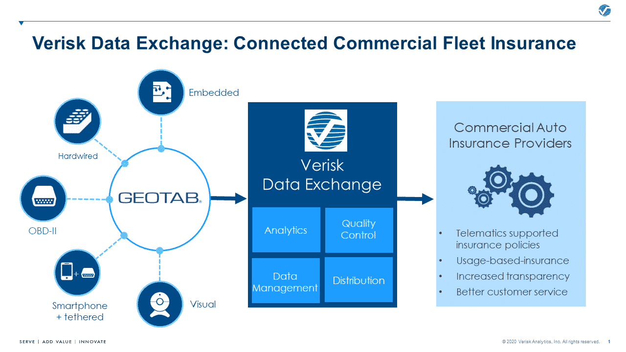
In response, telematics vendors are developing more tools to evaluate at risk driving. For example, the free Verisk Data Exchange add-in was recently introduced to the Geotab Marketplace. It is a platform that allows both customers and their insurers to access the same smart analytics that impact insurance premiums.

Usage Based Insurance App

Telematics is the Key to UBI

Advanced telematics is what makes Usage Based Insurance possible. Over the years, telematics providers and their partners have proven the value of telematics data. The information at our fingertips identifies risky driving behaviors. More important, we can use it to improve and correct them with driver training. In contrast, not acting on the information we have increases liability. But that is easily corrected as shown in the video below. Clearly the benefits that make companies more efficient and competitive outweigh any concerns over increased liability. Usage Based Insurance rates are another potential cost savings to add to that return on investment.

Usage Based Insurance Drives Driver Improvement

Improving driver behavior based on telematics data is easy to automate. Apps like Predictive Coach do all of the heavy lifting. There are also traditional courses like the National Safety Council Defensive Driving Course. A combination of ongoing and individually targeted training raises driver safety awareness and creates a culture of safety. Doing that will more than pay for itself in the long run, not to mention reducing your company liability. Proactive training increases the opportunity to reduce insurance premiums with new and innovative insurance plans like Usage Based Insurance. Ultimately the incentive to improve driving behavior for lower insurance rates will drive the success of initiatives like Vision Zero, making the roads safer for us all.

What the Future Holds

In conclusion, Transport Topics recently stated rising insurance premiums are a perennial stress for many motor carriers, many of which are now installing telematics systems with the latest safety technologies to mitigate cost increases. This is a positive trend for the trucking industry, and more carriers should fully embrace these technologies as they soon will become necessary to operate a safe, efficient and, ultimately, more profitable trucking fleet.

We agree and are here to help you get the technology in place, and use it to create positive change.
GEotab GO9 GPS Vehicle Tracking
Fleet Management Platform
Mobile Phone GPS Tracking App
Fleet Weather Service