Some Statistics Regarding Roadside Inspections

Understanding Roadside Inspections

Most drivers dread having to deal with a roadside inspection. That dread is well founded when you consider that the drivers career is on the line every time he faces off with a DOT inspector who is just doing his or her job. Being able to anticipate what inspectors are focusing on can be a great help.

We recently found a web page that contains interactive tools that can really give the driver an edge. It contains statistics regarding roadside inspections that are searchable by state, violation type, vehicle weight, fleet size and much more. For instance, if you are going to be driving in Arkansas, you can do some quick research to see how many inspections are being conducted and what kind of violations are being cited.

FYI, Arkansas was picked totally at random, we are not picking on them.

Roadside Inspection Activity

The chart below shows that in 2020 in Arkansas there were very few Federal Inspections, but State enforcement officials were very active. About 25% of inspections are full inspections, so best to make sure my logs and inspection records, as well as my vehicle, are in tip top shape.

It also looks like the Federal inspectors were a little more stringent with drivers than local enforcement, but local enforcement was much more stringent regading vehicle infractions.

Roadside Inspection Activity AR

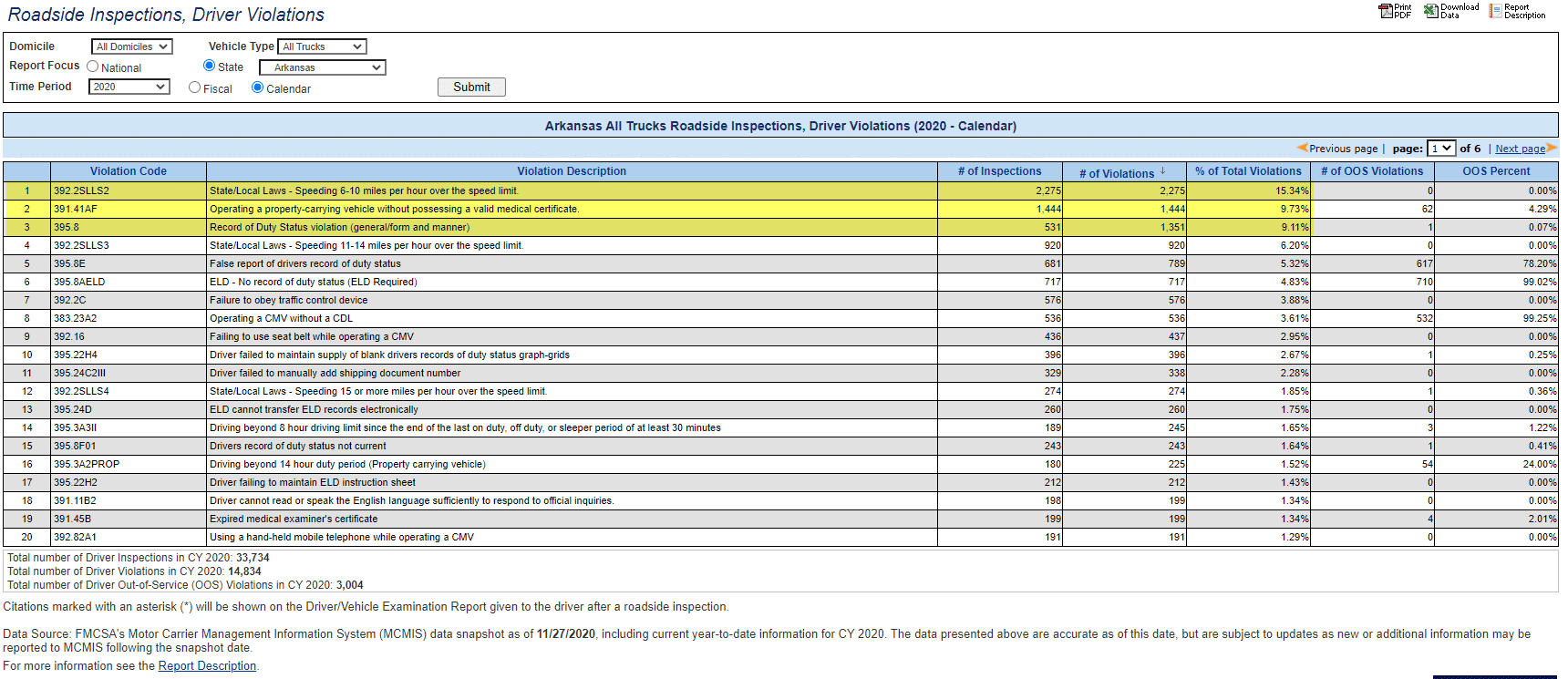
Driver Violations

Looking at the top 3 driver violations cited, it would seem that most violators were pulled over for a relatively minor speeding infraction of 6-10 mph over the speed limit. Common sense tells us that obeying the speed limit while driving in Arkansas is its own reward.

Driver Violations AR

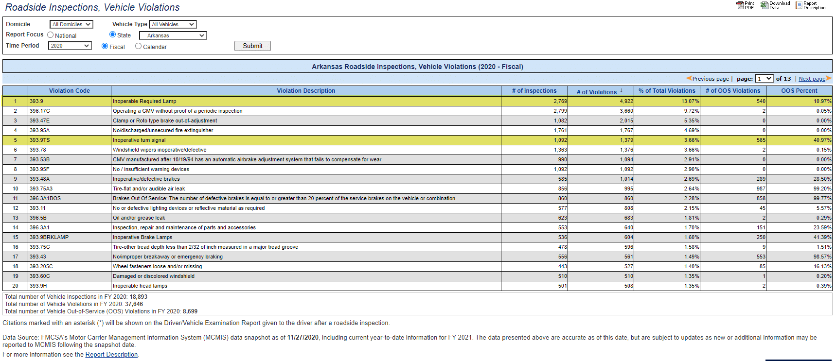
Vehicle Violations

Now that you have been pulled over for driving 7 mph over the posted speed, you can bet the inspector is going to check all of your lights and not miss a thing. Inoperative turn signals and lights will have you taken out of service in Arkansas.

Vehicle Violations in AR

Monthly Trends in Roadside Inspections

Understanding the roadside inspection trends by month can also be very interesting. From the chart below we speculate that after the initial COVID 19 shutdowns either enforcement was staying home or drivers were. It would be interesting to dig deeper to see if this is actually a seasonal trend based on some other factor.

Roadside Inspections by month in AR

Information is Power

Understanding the trends based on the factors discussed is certainly interesting and give drivers an edge, BUT nothing takes the place of constant vigilance when it comes to vehicle and driver safety. Our goal is for every driver to arrive home safely after every trip. No exceptions!

GEotab GO9 GPS Vehicle Tracking
Fleet Management Platform
Mobile Phone GPS Tracking App
Rugged Laptop 3

Free Webinar – Smart Fleet = Smart Government

Smart Fleet = Smart Government

Way beyond the average free webinar content…

Free webinars have become commonplace in our new normal, but some pack more punch than most. With so many integrated technologies available for managing government fleets, it is hard to single out the ones that offer the highest return on investment. In this free webinar we do just that, show you the technology that addresses some of the biggest issues facing government fleets today.

Smart Fleet = Smart Government

Live on November 4, 2020 at 2:00 PM EST

There is not much time left to register for this FREE webinar event.

Free Webinar Smart Fleet = Smart Government

Learn How to Maximize Government Telematics Data

Finding increasing value in the data you are collecting is a tough job, especially in today’s uncertain economic climate. As health, EMS, and public safety spending increase and tax revenues decrease, Government Fleet Managers are being asked to do more with less, and without sacrificing safety and compliance. Telematics is an amazing tool to analyze your operations, pinpoint strengths and weaknesses, all while ensuring that safety and compliance are maintained at the highest levels.

In this free webinar you will learn about tracking compliance and levels of service for your Public Works fleet, strategies that will help blaze a path forward to your electrification goals and how telematics goes beyond its traditional use as a fleet management tool to optimize smart transportation and Vision Zero initiatives.

Key takeaways:

  • Learn how to manage mixed fleets and assets including Public Works to:
    • Track compliance and levels of service
    • Monitor material usage
    • Maintain core services citizens depend on
  • Build an electrification strategy that is tailored to you specific fleet’s needs
    • Learn how an EV Suitability Assessment can help blaze a path forward to your future electric fleet.
  • Hear how data can be transformed into actionable smart city insights to
    • Understand local transportation patterns, traffic safety and road conditions
    • Reduce greenhouse gas emissions
    • Justify investments in digital infrastructure

MEET THE SPEAKER

Free Webinar Meet the Speaker
GEotab GO9 GPS Vehicle Tracking
Fleet Management Platform
Mobile Phone GPS Tracking App
Rugged Laptop 3

Introducing Geotab Keyless Entry Solution

Geotab Keyless Entry

Contributed by Kim Thoman


Streamlining fleet technology is what we do, and it just keeps getting better! Introducing the launch of Geotab Keyless. Designed to help right-size your fleet, this secure and scalable solution will also assist in maximizing vehicle usage and reducing the cost of vehicle ownership. Geotab Keyless is an economical robust solution that assists in the delivery of keyless entry and remote vehicle access with the benefit of added security features.

Geotab Keyless

What type of fleets will benefit from Geotab Keyless?

What type of fleets will benefit from Geotab Keyless?

  • Motorpool – Corporate or government fleets that only need vehicles on an occasional basis or a fleet manager who needs to pool vehicles together for multiple drivers to share can access vehicles anytime and anywhere with Geotab Keyless.
  • Car Share – Whenever your car share customers are ready, this real-time solution is here to bring them closer any day, any hour or minute.
  • Dealerships – Test driving has never been this convenient. Give your team access to digital keys to provide a harmonious customer experience.

Highlighted features include:

Highlighted features include:

  • Works for all vehicle makes and models that support keyfob entry.
  • Offers the ability to lock and unlock vehicles via Bluetooth connection on a driver’s smartphone, using NFC fobs and/or through the GO device’s cellular connection.
  • Helps provide secured access to vehicles using a third-party phone app even when parked outside cellular coverage areas.
  • Enables multiple drivers to share vehicles without the need for physical key handoffs.
  • Helps to eliminate lost, broken or stolen keys and prevents vehicle lock-outs.
  • Helps limit vehicle access to authorized users only or restricts access to particular time periods.
  • Integrates with a number of best-in-class reservation systems.
Enjoy the convenience of locking and unlocking vehicles through your smartphone, while benefiting from connected vehicle insights. Improve fleet efficiency, optimize resources and more with this best-in-class digital key solution.
GEotab GO9 GPS Vehicle Tracking
Fleet Management Platform
Mobile Phone GPS Tracking App
Rugged Laptop 3

Smart City Innovations

Smart City Innovations

Smart City Technology is All Around Us

Smart City Technology is surfacing all over the United States. To most of us, smart city is a broad term used to describe how technology will make things better in the future, but it is hard to come up with a quick example of how technology actually makes a city smarter.

Smart 50 Awards in partnership with Smart Cities Connect honors the 50 most transformative smart projects each year. Among 2020 award recipients are several projects that rely upon GPS tracking and telematics. With that in mind, we have picked three of the 50 award winning projects to share with and inspire our readers. The official summaries of those winning projects follow.

San Jose Smart City

Smart City San Jose, CA

Emergency Response Times Improved

San Jose transformed traditional emergency vehicle preemption through a multi-domain solution expanding Central Traffic Management, integrating real-time CAD, and connecting vehicle presence. The results: response times fell by 24 seconds per trip benefiting life and safety; reduced accidents for first responders; and over $1.5 million in higher reimbursements.

After failing to meet mandated response times, the City of San Jose sought methods to improve response times. Traditional means to improve response times was through the further deployment of emergency vehicle preemption hardware to allow emergency vehicles faster passage to their destinations. In late 2016, emergency vehicle preemption equipment had been deployed at approximately one-third (or 336) of the city’s signalized intersections. Because this system required hardware installation at each intersection signal, system expansion and ongoing maintenance was too costly– at a rate of approximately 15 intersections per year, and an average cost of $15,000 per intersection and total cost of $9 million.

The City of San Jose made the decision to take a new approach to providing emergency vehicle preemption that leverages existing infrastructure and software systems already in use and eliminating the need for costly new hardware installation and maintenance. Creating a solution that is geo-aware, route in advance, real-time, and fast to deploy protects the lives and safety of residents, protects first responders from high in-transit accident rates, and provides the City with significantly higher revenue in the form of reimbursements.

Response times fell by 24 seconds per trip, preserving life and safety for residents Pre-cleared intersections reduce accidents for first responders in transit -Meeting response thresholds enables over $1.5 million in higher reimbursements from County partners -Solution saves the community 90% of the cost of traditional emergency preemption.

Pittsburgh Smart City

Smart City Pittsburgh, PA

Trash Collection Improvements

Sensors embedded within Pittsburgh’s trash receptacles measure the fill level of each container and transmit that information to the people responsible for servicing them. Waste collection process is made more efficient by only picking up containers above a certain fill level (e.g. 80%), saving money, time, and reducing environmental impact.
The project improves the efficiency of the waste collection process by measuring and reporting the fill level of every container, and then dispatching the collectors to only the containers which actually require collection. Pittsburgh sought to remove inefficiency within their trash pickup operation while reducing their carbon footprint and promoting costs savings. With the Relay system, they were able to maintain an accurate inventory of the locations and fill levels of more than 1,300 smart containers throughout the city.

The data gave them confidence in the decision to consolidate all of their containers into a centralized litter division, and also to reduce the staff responsible solely for picking up trash from 25 crew members down to 9. The 16 additional staff members have time to work on other tasks, which had been de-prioritized with the focus on trash collection. By picking up only the containers reaching 75% or 90% full, the city is saving money on truck drivers, laborers, fuel costs, equipment costs, and depreciation costs from the reduced wear and tear on collection trucks. Drastically cutting the amount of time these trucks are on the road also dramatically reduces the city’s environmental impact.

Streets are cleaner (less litter), containers are no longer overflowing, heavy diesel trucks are taken off the road (reducing greenhouse gas emissions and traffic delays to nearby drivers), taxpayer dollars are not going towards unnecessary trash collection, deferred public works responsibilities can have freed-up resources refocused on them.
Washington DC Smart City

Smart City Washington DC

Public Transit Improvements

Luminator Technology Group (Luminator) and the Washington Metropolitan Area Transit Authority (WMATA) partnered to install digital displays across the metro area to provide passenger information, including real-time arrival and departure times. The agency improved rider information and gained operational efficiencies through centrally managed updates.
In an effort to further connect the Washington D.C. metro area to real-time information, this implementation across the Washington Metro Area Transit Authority’s (WMATA) service area resulted in increased and improved access to key route information, with WMATA seamlessly updating displays and real-time data from a single location. By eliminating the need to manually update paper signs, the project brought mutual benefits to riders and the agency. Riders have access to real-time information incorporating any delays or closures, meanwhile, WMATA has decreased labor costs associated with manual changes of paper signage. With Luminator’s involvement in WMATA’s Capital Improvement Plan (CIP), the transit agency is able to provide information that increases the intelligence and efficiency of the solution, making stations brighter and easier-to-navigate. Luminator is also increasing efficiency throughout the system enabling future expansion.
WMATA currently has 400 of Luminator’s digital passenger information systems installed across its service area and will add another 400 over the next five years. With Luminator’s support, WMATA is improving and advancing these displays to meet the needs of approximately 120 million annual bus riders.

Congratulations to the Smart 50 Award Winners.

We congratulate all of the winners and look forward to participating with our City and County Government clients to welcome the future with Smart City initiatives. To learn more about the Smart 50 Awards visit https://spring.smartcitiesconnect.org/.
GEotab GO9 GPS Vehicle Tracking
Fleet Management Platform
Mobile Phone GPS Tracking App
Fleet Weather Service

Green Fleet Dashboard to Visualize Your Changing Environmental Impact

Green Fleet Dashboard – Free Marketplace Add In

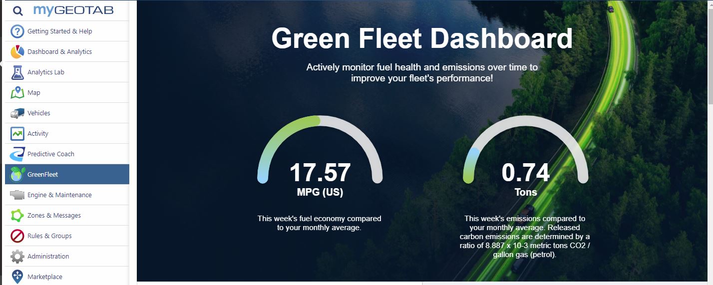
The Green Fleet Dashboard is one of Geotab’s latest innovations. It is a free add in available from the Geotab Marketplace. Have you seen it yet?

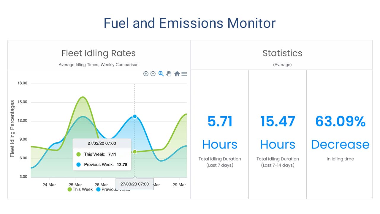
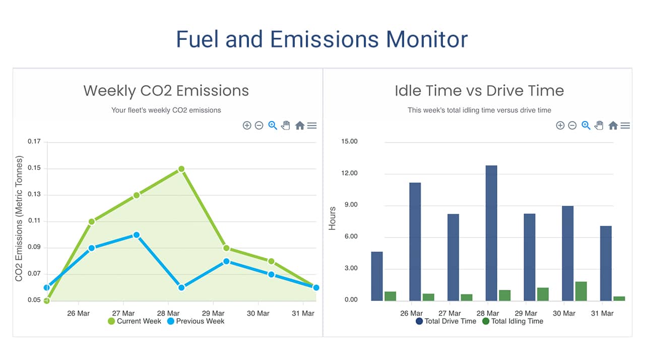
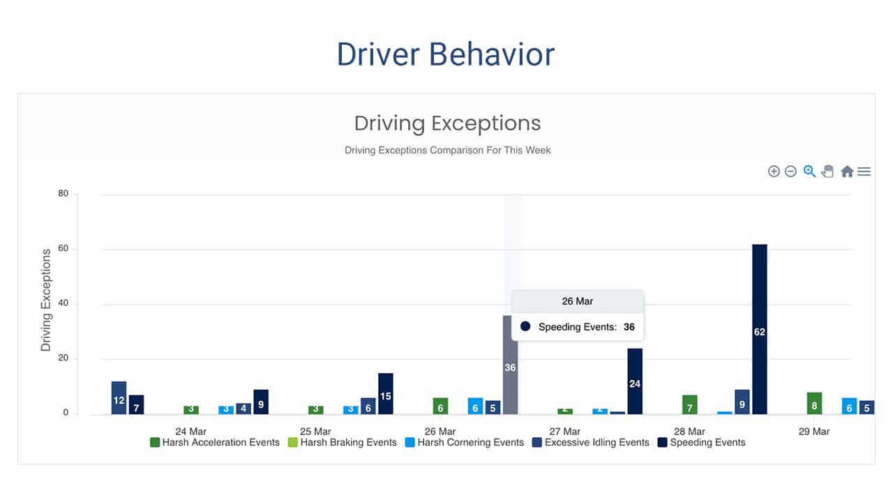
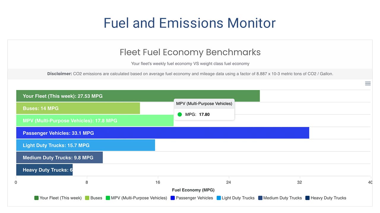
This add in displays a fleet’s efforts to reduce their environmental impact. It helps fleet managers to visualize their progress with improving fuel economy and reducing emissions. The dashboard provides key metrics on fuel useage and driving behaviors, that provide quick insight into how well your fleet is performing, and flags opportunities for improvement.

Green Fleet Dashboard

Green Fleet Dashboard Features

  • Monitor your fleet’s monthly and yearly average fuel economy
  • Track monthly and yearly emissions
  • Track key performance indicators related to fuel efficient driver behavior, including:
    • idling time
    • speed
    • harsh acceleration and braking
  • Highlight best and worst performers
  • Compare your fleet’s performance with fleet industry benchmarks

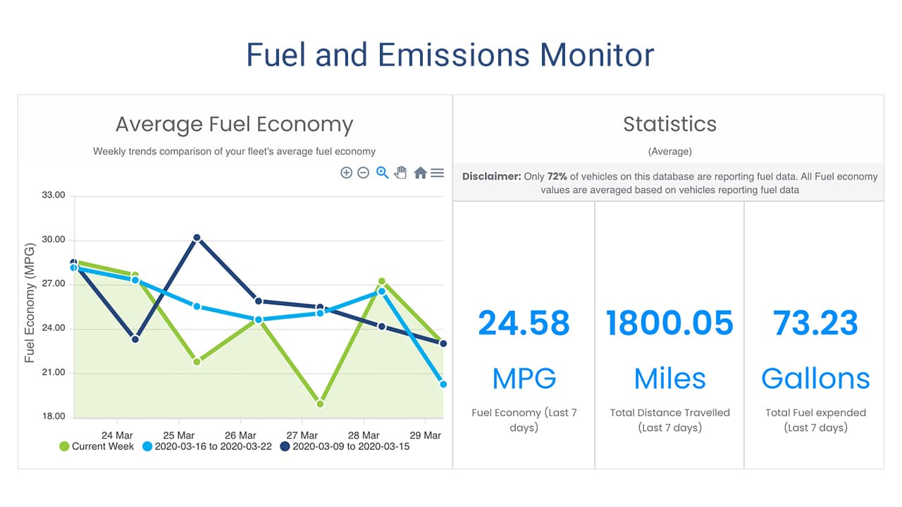
The Green Fleet Dashboard add in provides you with exceptional visual information. The graphics are easy to digest and keep you focused on achieving your green fleet goals. What a great tool to stay focused on reducing your environmental impact!

Below are some examples of the charts and graphs the Green Fleet Dashboard delivers.

Installing the Green Fleet Dashboard

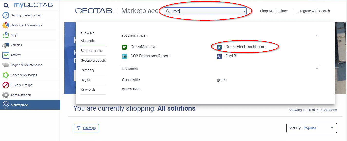
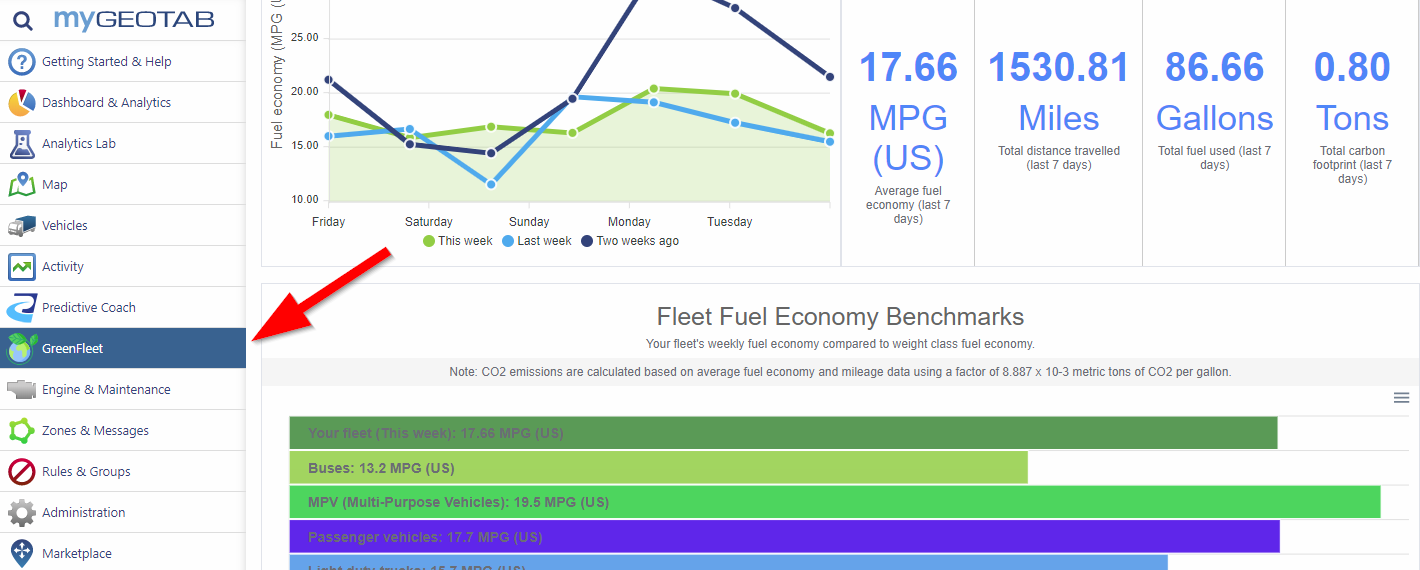
To install the add in, simply log into your Geotab account and select “Marketplace” at the bottom of the main menu. Once in the Marketplace, begin typing “green fleet” into the search bar until you see the Add In listed. Click on the add in logo, then click install on the next page. Once installed, you will see the new dashboard in your Geotab menu. Easy as 1-2-3!

Just click to expand the images below.

1

Search Geotab's Marketplace

2

Install Now

3

Green Fleet Dashboard Installed
GEotab GO9 GPS Vehicle Tracking
Fleet Management Platform
Mobile Phone GPS Tracking App
Fleet Weather Service